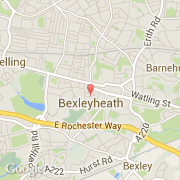
Localidad de Bexleyheath (England)

reino-unido

Informations

Cifras

Código del país :
GB
Código postal :
DA6
Latitud :
51.45490
Longitud :
0.13808
Huso horario :
Europe/London
Universal Time :
UTC
Horario de verano :
Y

La localidad de Bexleyheath pertenece (de mayor a menor) a la nación England, al condado Kent y al distrito Bexley.

La página web de Bexleyheath es http://www.bexleyheath.towntalk.co.uk

Ciudades próximas

  • Bexley ~2 km
  • Barnehurst ~2 km
  • Northumberland Heath ~2 km
  • Belvedere ~3 km
  • Welling ~3 km
  • Lesnes Abbey ~4 km
  • Erith ~4 km
  • Sidcup ~4 km
  • Abbey Wood ~4 km

El transporte en Bexleyheath

Aeropuertos internacionales
City ~8 km
Stansted ~48 km
Gatwick ~41 km
Otros medios de transporte
Biggin Hill ~16 km
North Weald ~30 km
London St Pancras ~20 km
St Pancras Railway Station ~20 km
London Euston Railway Station ~20 km
Booking.com

Únete a nosotros !

¿Te gusta? Compártelo!